River Atlas Reboot 2021
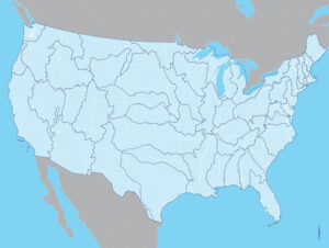
United States: Political / Hydrological, 2006 / 18’h x 24’w / book plate
In 2006, I created a limited edition artist book – a river-centered atlas of the United States entitled, Political / Hydrological: A Watershed Remapping of the Continental United States. This title was promptly corrected when I shared the finished product with Denis Wood (geographer and author of several thought provoking books on mapping) – it should be the Contiguous or Conterminous United States, not the Continental United States. Oops!
Over the years I’ve realized that the project contains (and lacks) a number of other details that need correcting, too. Because I aspire to publish the atlas for a broader audience, I need to address these issues AND assemble a text to accompany the maps, serving as both an explanation and an outlet for creative engagement with the implications of redefining our national identity around freshwater resources. Oh boy. For many years, the prospect of tackling this task has felt overwhelming, terrifying, defeating, and beyond the scope of my capabilities. Now I’m older. Maybe wiser, maybe not. Regardless, I am ready. I’ve decided that 2021 is the year that I resurrect this work, adding important features to the maps (lakes!) and writing the text that helps them come alive. I’ll do it in baby steps – I plan to post here at least once a week, offering a new layer of insight into the project each time so that by the end of the year I’ll have accumulated 52 pieces of writing that may be edited, synthesized, extrapolated upon…to make a book of this thing.
To start, I’d like to share the original introduction I wrote for the artist book here. It contains a quote from John Wesley Powell, who, as the second director of the USGS from 1881-1894, presented Congress with a proposal to delineate the arid States of the West based on watershed divides:
In a group of mountains a small river has its source. A dozen or score of creeks unite to form the trunk. The creeks higher up divide into brooks. All these streams combined form the drainage system of a hydrographic basin, a unit of country well defined in nature, for it is bounded above and on each side by heights of land that rise as crests to part the waters. Thus hydraulic basin is segregated from hydraulic basin by nature herself, and the landmarks are practically perpetual…Such a district of country is a commonwealth by itself. The people who live therein are interdependent in all their industries. Every man is interested in the conservation and management of the water supply, for all the waters are needed within the district. The men who control the farming below must also control the upper region where the waters are gathered from the heaven and stored in the reservoirs. Every farm and garden in the valley below is dependent upon each fountain above…Thus it is that there is a body of interdependent and unified interests and values, all collected in one hydrographic basin, and all segregated by well-defined boundary lines from the rest of the world. The people in such a district have common interests, common rights, and common duties, and must necessarily work together for common purposes. Let such a people organize, under national and State laws, a great irrigation district, including an entire hydrographic basin, and let them make their own laws for the division of the waters, for the protection and use of the forests, for the protection of the pasturage on the hills, and for the use of the powers. This, then, is the proposition I make: that the entire arid region be organized into natural hydrographic districts, each one to be a commonwealth within itself for the purpose of controlling and using the great values which have been pointed out. There are some great rivers where the larger trunks would have to be divided into two or more districts, but the majority would be of the character described. Each such community should possess its own irrigation works; it would have to erect diverting dams, dig canals, and construct reservoirs; and such works would have to be maintained from year to year. The plan is to establish local self-government by hydrographic basins.[1]
What would the West look like today if Congress had accepted this proposal? This is the question that the atlas has always intended to ask – how would our society, our laws, our systems of organization, our urban management, our individual identities be different today if water was at the center of our social construct? This year I will attempt to extrapolate on this question and to imagine potential answers in order to offer a different, more interconnected vision of ourselves and our world.
[1] deBuys, William, ed. Seeing Things Whole. Washington, DC: Island Press, 2001.
