What’s With the Map?
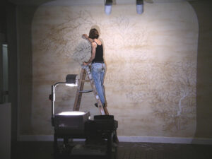
Haw River Drawing #1 (Installation shot), 2005 / 10’h x 15’w / ground river rock, river water (Alcott Gallery, UNC Chapel Hill)
During my first year of graduate school, I created a temporary installation for the “New MFA Show” at UNC, Chapel Hill’s Alcott Gallery. I made Haw River Drawing #1 (pictured above) by painting ground river rock directly onto the gallery wall and then using river water to erase each stream from the field of pigment, a process intended to evoke the way that rivers mark their paths on the earth.
Several faculty met with me to discuss / critique the piece, and when Jeff Whetstone walked in, he asked, “What’s with the map?” Ummmmmm…..what map? I had gotten so wrapped up in the materiality and process of collecting rocks, grinding them into pigment, painting them onto the wall, and tracing the stream networks that I lost track of the fact that I wasn’t just making a drawing – I was, in fact, making a very large river map.
It was elin o’Hara slavick who blew the lid off of my head, though, when she opened my mind to the critical dialogue around maps and encouraged me to continue using them as a visual language. I have never looked back.
All creative practice is a recombining of old ideas to facilitate new ones. Mapping is no different; it is a process of overlaying and merging ideas about the world back upon the world to create new ways of seeing. Although I came to mapping intuitively, I have since learned that the art and science of cartography aligns well with the activist in me.
There are two points about maps that I find particularly interesting:
1. Although we are often unaware of it, maps are subjective—they reflect particular value structures. We often take for granted that maps are useful. They function. We can measure distance and elevation through their symbols. They help us get from point A to point B. As such, we think of them as objective documents. And technological advancements such as GIS and remote sensing have only increased their credibility along these lines. We often forget about the cartographer behind the scenes who is making decisions about what to put in and cut out of the picture. However, Denis Wood nicely states that, “maps, all maps, inevitably, unavoidably, necessarily embody their authors’ prejudices, biases and partialities (not to mention the less frequently observed art, curiosity, elegance, focus, care, imagination, attention, intelligence and scholarship their makers’ bring to the labor).”[i]
2. Maps do not only represent, but also create the worlds in which we live. Because there is a strong link between visual and intellectual realms of knowledge, maps get into our heads. They create a picture that informs our understanding of the world—the geographical imagination. This individual and collective consciousness about our social and physical landscapes in turn informs the way we act in the world. To this end, John Pickles, in his book A History of Spaces, writes, “The world has literally been made, domesticated and ordered by drawing lines, distinctions, taxonomies and hierarchies: Europe and its others, West and non-West, or people with history and people without history. Through their gaze, gridding, and architectures the sciences have spatialized and produced the world we inhabit. And, indeed, this is perhaps the crucial issue: maps provide the very conditions of possibility for the worlds we inhabit and the subjects we become.”[ii]
Throughout most of history, maps have been funded and produced by powerful governing agencies (i.e. military, resource management, taxation, and property management). Their particular ideas, interests, and values inform the maps that we often deem to be “objective.” The danger in continuing to think about maps this way is that it doesn’t leave much room for change. Maps are one of the ways in which dominant ideologies perpetuate themselves.
Ever since I made that first drawing on the gallery wall, I have continued to create counter-mappings of possibility and critique. Through the process of imaging the world as I believe it ought to be, I attempt to question current power structures and imagine new, more integrated visions of the world in which we live.
Also, just dropping a more thorough paper I presented on this subject, mostly focused on my river atlas, Political/Hydrological here.
[i] Denis Wood, The Power of Maps, (New York: The Guilford Press, 1992), 24.
[ii] Pickles, John, A History of Spaces: Cartographic reason, mapping, and the geo-coded world, (London: Routledge) 5.

3 Comments
Permalink
You’re brilliant and I love you!
Permalink
I have been a “mapper” all my career and somehow you were able to capture in one blog post the entire essence, good, bad, and at times, extremely ugly, of everything I do.
Keep creating Lauren, with your pigments and your rivers and your maps and definitely your words!
Permalink
Nice read. Fresh food for thought. Thanks for putting it out there. Great origins story too!
Comments are closed.